
The week of surveying by archaeology students here at Chawton House Library has come to a close. This is their final blog and summary written by Senior Teaching Fellow at the University of Southampton, Timothy Sly. We are delighted that the group enjoyed carrying out the survey and eating copious amounts of Chawton House Library’s home baked cakes! We hope to welcome more archaeology students back to the Library in the near future.
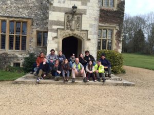
Figure 1: Team photo of all staff and students from the end of our last working day.
So, our five-day survey has come to an end, although we cannot claim to have finished surveying Chawton House Library. All our different survey techniques (topographic and detail, 3D building survey and electrical resistance survey) have yielded useful results, but we will need time to analyse and ‘unpick’ and phase what we are seeing in the data.
We did not manage to finish surveying the ‘wilderness’ area, but the data we have collected will be combined with the LiDAR (a remote sensing technique that uses a clever combination of lasers and radar to give a three dimensional surface image) coverage, to hopefully improve the topographic model within this wooded area. There are earthworks showing up in the LiDAR data, but as the resolution of the LiDAR is only 1m x 1m and the LiDAR does not seem to have penetrated the tree canopy particularly well, there is room for improvement – and hopefully this is where our data will be useful. Surveying in wooded (and jungle!) environments is always a challenge, as generally you cannot rely on GPS; line of sight devices like total stations will have limited visibility, necessitating the setting up of more stations, hence slowing the speed of survey. If we return to the site, finishing the survey of the ‘wilderness’, to a high level of accuracy, would be a priority.
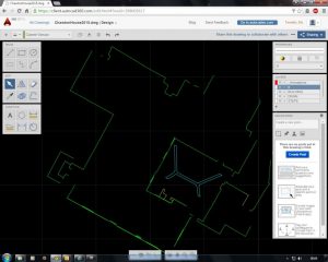
Figure 2: Plan survey of the exterior of the main house (not complete)
The 3D building survey went well, with Penny Copeland and her team concentrating on the cellars below the south wing of the main house, and Catriona Cooper and her team surveying the ground floor rooms above these cellars. The outdoor survey team also did a plan of the exterior of the building, which looks to have considerably more detail than the Ordnance Survey map. As with our recent survey of Bodiam castle, all the different surveys are working on the same set of grid coordinates (O.S.), making it possible to combine all these different surveys, in both 2D and 3D. Penny has been excited about some of the features that have been surveyed in the cellars, both their morphology and alignment. There are hints that we may be dealing with the remains of an earlier (pre- Tudor), stone building; remains which have been reused and built over. Phasing of the survey plans, and perhaps further survey work, may help to answer these questions.
The electrical resistance survey work carried out by Dominic Barker (with valuable assistance from Sam Griffiths) and his team of students went well and yielded results (the technique worked in this environment). The South Lawn yielded interesting results, but, much to my disappointment, given the asymmetrical nature of the building, probably no ‘lost’ wing of the main house. A series of rectilinear ‘high’ resistance features, being ‘cut’ by linear ‘low’ resistance features were discovered, perhaps representing earlier garden features. Once we have the data geo-referenced we can see if these match up with the ‘Lime’ avenue that runs away from the house, in a southerly direction. We also managed two squares of survey at the extreme east end of the walled garden, and again there are features visible (again, perhaps earlier garden features?). More processing of the data needs to be done, using specialist geophysical software, and all the final results need to be geo-referenced. The electrical resistance survey could perhaps be extended to cover the entirety of the lawn, and it might be worth trying GPR (Ground Penetrating Radar) over the gravel paths that surround the main house.
The students now have until the 14th May to write up their final survey reports, for which they have a detailed rubric. But perhaps it can best be summed up as this: what do we know about Chawton House Library and its grounds that we did not know at the beginning of this week, and how can we use our new data (along with other sources: historical, archaeological, grey literature reports, paintings, LiDAR, O.S. maps etc.) to demonstrate this? On a personal note I would like to thank all the staff and volunteers at Chawton House Library for making us feel very welcome and for providing invaluable logistical support. Also, I think most of us ate our own body weight in delicious home baked cakes from the tearoom, over the course of the week.
By: Timothy Sly